ihub logoMn/DOT Newsline banner
Search Newsline for:  In the year:
October 19, 2005    No. 168
  This week's top stories
 Highway roundabouts: driving in circles can improve intersection safety
 Culkin rest area closed to I-35 motorists
 Land use, policy trends, airport maintenance top AirTAP agenda
 Transit’s Billiar will lead new ‘Safe Routes to School’ program
 Annual expo focuses on maintenance-related activities

 Highway roundabouts: driving in circles can improve intersection safety

Prior Lake road sign
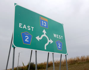
This sign on Hwy 13 and Scott County Road 2 gives motorists a graphic notice as they approach the new roundabout. Photo by David Gonzalez

Whether he’s heading west to go fishing or east with a truckload of apples to market, grower Denny Havlicek turns the same way at the first intersection he encounters—right.

That’s because the intersection of Hwy 13 and Scott County Road 2, a few miles from his orchard near New Prague, is a roundabout.

Roundabouts replace standard highway intersections controlled by stop signs or traffic lights. They create a one-way, circular path around an intersection where traffic flows in a counter-clockwise direction.

Drivers merge into the one-lane path at reduced speeds, turning off when they reach their exit.  

Ken Johnson, a Metro District design project engineer, said a roundabout design was chosen for the rural Hwy 13/County Road 2 intersection due to its high rate of serious injury crashes. During the past five years, he said, crashes resulted in two deaths and 50 serious injuries.

Johnson said roundabouts eliminate potential traffic conflicts that can result in crashes in a standard intersection. A typical intersection has 32 conflict points, 16 of which are crossing conflicts. The crossing conflicts lead to the most dangerous crashes: right-angle or left-turning collisions.  

Medford roundabout
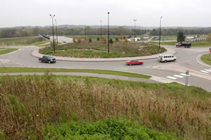
Motorists move around one of the roundabouts that connect I-35 with Steele County Road 12 in Medford. Landscaping improves safety on the roundabouts by helping drivers stay focused on the roadway. Photo by David Gonzalez

A roundabout, however, has only four merging conflict points. If a crash occurs with a merging conflict, it typically leads only to a fender bender, he said.

Since the roundabout opened in early September, there have been no crashes. It handles about 7,000 vehicles per day.

The Hwy 12/County Road 2 site is the second interchange using the roundabout design built by Mn/DOT. The first, which actually includes two roundabouts, was completed in 2002 near Medford. The twin roundabouts provide access via a county road from Interstate 35 to an outlet mall and other stores near the freeway.

Chances are good, highway designers say, that there will be more.

Jim Roberts, resident engineer at Rochester/District 6’s resident office at Owatonna, said the twin roundabouts have worked well and earned support from business owners, city officials and motorists.

Johnson said roundabouts, prevalent in Europe and on the East Coast, are gaining support quickly in other parts of the United States.

Wisconsin, for example, has constructed 12 roundabouts and plans to build 60 more, he said.

Jim Roberts, resident engineer at Owatonna, directed construction of the twin roundabouts adjacent to I-35 in Medford. Photo by David Gonzalez

Several Minnesota cities now use roundabouts including Minneapolis, Stillwater, Maplewood and Chaska.

Mankato/District 7 plans to use a pair of roundabouts to connect Steele County Road 7 and Hwy 14 when it rebuilds the highway between Waseca and Owatonna.

Peter Harff, a District 7 design project engineer, said using roundabouts will allow the use of a narrower, less expensive bridge design.

“By using roundabouts,” Harff said, “we can eliminate traffic signals and build a lower-cost structure because we won’t need to have separate turn lanes on the bridge.”

At his booth at the Midtown Farmers’ Market in Minneapolis, Havlicek said the new roundabout makes his frequent travels easier and safer.

“I first encountered them on a trip to the Netherlands,” he said. “It’s a very smart thing to do—and you’re a lot less likely to get hit than in an intersection.”

By Craig Wilkins


back

 Culkin rest area closed to I-35 motorists

Culkin rest area
The Culkin rest area on northbound I-35 between Barnum and Duluth closed on Oct. 18 after a 2004 evaluation of the Mn/DOT's rest area system determined that it did not serve a significant highway safety purpose. Photo courtesy of District 1

Mn/DOT closed the Culkin rest area on northbound Interstate 35 between Barnum and Duluth on Oct. 18.

The closing is a result of an evaluation of the rest area system Mn/DOT did in 2004, which found that Culkin did not serve a significant highway safety purpose.

“The department is looking at many options for streamlining the rest area system,” said Robert Williams, Mn/DOT’s rest area program manager. “Mn/DOT’s goal is not to take away from the system but to improve it to more directly meet the safety and service needs of motorists.”

Other stops along I-35 between the Twin Cities metro area and Duluth are able to serve these needs, Williams said. The Thompson Hill Travel Information Center south of Duluth and the Kettle River rest area north of Sandstone are 52 miles apart. Culkin falls between the two.

The optimum distance between rest areas is about 50 miles, which helps reduce drowsy driver accidents by allowing motorists to take regular breaks. Just a 10-15 minute stop can significantly improve drivers’ ability to drive more safely, said Williams. Rest areas that serve a significant safety purpose also:

  • Eliminate unsafe highway shoulder stops
  • Occur at critical locations for commercial trucks
  • Enhance comfort and convenience for motorists
  • Reduce excess travel and time spent searching for services

A 2004 report to the Legislature on the Mn/DOT rest area program includes information on the locations targeted for streamlining. Streamlining involves options such as partnerships, transfers to local government, closures of sites that no longer serve a highway safety purpose and looking at where sites may be needed.

Williams said that the department is still pursuing a potential partner to share costs and maintenance of the Culkin site, which opened in 1988 and is valued for its natural beauty and abundance of wildlife.

“Mn/DOT is exploring alternate or shared uses of the site with other state and local governments that will allow us to again provide minimal convenience services there,” said Williams.

For more information about Mn/DOT's system of rest areas, visit http://www.dot.state.mn.us/restareas.

By Donna Lindberg


back

 Land use, policy trends, airport maintenance top AirTAP agenda

The second annual Airport Technical Assistance Program Fall Forum, held Oct. 11-12, attracted city and county employees, airport consultants and Mn/DOT staff.

Land use around airports, state and national policy trends and airport maintenance were among the topics discussed at the second annual Airport Technical Assistance Program Fall Forum held Oct. 11-12 in Brainerd.

Approximately 90 city and county employees, airport consultants and Mn/DOT staff attended the two-day event, which was sponsored by Mn/DOT through the University of Minnesota Center for Transportation Studies in cooperation with the Minnesota Council of Airports.  

One of the goals of the AirTAP Fall Forum is to provide an atmosphere of information-sharing among people who daily operate and maintain airports, according to Peter Buchen, Airport Development Section manager in Mn/DOT’s Office of Aeronautics.  

Session highlights included:

Land use—Tina Axelrad of Clarion Associates gave a briefing on the findings and preliminary recommendations of the Mn/DOT-sponsored study on land use around airports and steps that can be taken locally to help assure compatible development near airports. The study's final report is expected by the end of the year.

State and national policy trends—A panel consisting of U.S. Rep. James Oberstar, State Rep. Mike Beard and State Sen. Ann Rest provided insights into aviation issues being discussed both nationally and within Minnesota.

Airport maintenance—Industry and airport leaders presented sessions on aircraft storage hangars maintenance, best practices for mowing and vegetation management, and fall and winter runway maintenance.

Airport economic impact—Dan Erkkila, a University of Minnesota professor, demonstrated use of the Airport Economic Impact Calculator—available on the Office of Aeronautics Web site—to help airports present their contributions to their regional economy.

Aviation trends—Jeff Hamiel, Metropolitan Airports Commission executive director, led a group discussion on the current state of aviation and the future of commercial service and general aviation.

For more information about AirTAP, visit http://www.airtap.umn.edu/index.html.


back

 Transit’s Billiar will lead new ‘Safe Routes to School’ program

Kristie Billiar
Kristie Billiar, Office of Transit, will coordinate Minnesota’s participation in the new federal “Safe Routes to School” program. Photo by David Gonzalez

Kristie Billiar, Office of Transit, will coordinate Minnesota’s participation in the new federal “Safe Routes to School” program.

Until accepting her new responsibilities, Billiar served as Mn/DOT’s pedestrian planning coordinator.

The program’s goals include encouraging children to walk or bike to school and to help combat the national epidemic of obesity and related diseases such as diabetes among young people.

The program also seeks to reduce traffic congestion and related safety hazards at schools caused by the high percentage of students who are driven to school.

Funding and direction for the new program comes from the recently passed SAFETEA-LU legislation—the Safe, Accountable, Flexible, Efficient Transportation Equity Act: A Legacy for Users—that provides federal funding for state transportation programs. The legislation requires that all states support the program and appoint a coordinator.

Mn/DOT received $1 million to coordinate the program for its first year.

Billiar will work with school districts, law enforcement agencies, health educators and local units of government to implement the program.

Program funds, she said, will be used to improve lighting, signing and other infrastructure needs. The program will also involve communities to encourage parents about the benefits of biking and walking to school and integrating the activities into community life with the support of educators, police departments and other community resources.

“Some students have brief periods of physical activity such as gym or sports, but walking and biking provide regular, moderate-level activity on a regular basis,” Billiar said.

School and community leaders, she said, will be asked to support the program by enforcing laws related to driving in school zones, using pedestrian crosswalks and bicycling safely.

By Craig Wilkins


back

 Annual expo focuses on maintenance-related activities

Ken Nelson, Mn/DOT Work Zone Safety Communications Committee member, talks with two attendees at the Fall Maintenance Expo, which took place at the St. Cloud Maintenance Facility on Oct. 5-6. Hundreds of people interested in roadway maintenance were on hand, as were dozens of exhibitors. The expo featured exhibits, training on various maintenance-related subjects and a truck ‘roadeo,’ which tested contestants' driving skills. Photo and story by Kevin Gutknecht


back