|
|
|
|
Winter re-emerges with powerful mid-March snowstorm |
|
|
 |
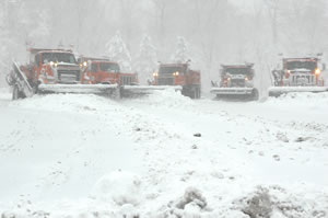
Snowplow drivers work on I-494 between So. Robert Street and Hwy 13. Photo by David Gonzalez |
Nature flipped Minnesota over like a snow globe on March 13, turning a weekend with temperatures in the 50s into a world deep with wet, heavy snow that disrupted traffic and life in general for most of the state’s residents.
But instead of spreading the snow evenly, the storm spared the state’s northern half. The storm, accompanied by strong winds and plummeting temperatures, dropped as much as 18 inches of snow on the state’s southern tier, including the Twin Cities metro area.
Justice served, some might say, for a winter that had previously plagued the northern part of the state with freezing rain, ice, high winds and cold while leaving the rest of Minnesota relatively unscathed.
Until Monday, the 13th.
The storm arrived in time to scramble the morning commutes for thousands of people, closing schools and clogging many roads and highways.
Mn/DOT was forced to temporarily close some highways including parts of Interstate 90 in southwestern Minnesota, Hwy 52 between Cannon Falls and Zumbrota, and sections of Hwy 60 at Butterfield and at Wilder.
Gordon Regenscheid, maintenance operations manager at Mankato, said the district closed a part of I-90 near Alden because two jackknifed semi-trailer trucks were blocking the freeway.
Several advisories urged motorists not to travel during the storm.
Jeff Butson, operations superintendent at District 8, said snowfall at Willmar was scant, but that the Marshall and Hutchinson areas were hit hard by the storm.
He said crews were hampered in regaining bare pavement by wind-blown snow that froze on road surfaces.
 |
Five trucks at the Mendota Truck Station are prepped and ready for snowplowing. Photo by David Gonzalez |
In the Twin Cities area, snow-compacted streets and highways, high winds and heavy Monday morning traffic combined to immobilize scores of transit buses and caused an outbreak of crashes, spinouts and vehicles sliding into medians and ditches.
The wet, slippery snow made difficult going for semi-trailer trucks and other large vehicles; jackknifed semis caused road and lane closures that led to more delays.
Mn/DOT maintenance crews faced off with the storm on Sunday afternoon when the snow first began to fall.
In the Twin Cities metro area, nearly all of the Metro District’s 249 snowplows were pressed into service. Mark Fischbach, district snow and ice coordinator, said maintenance crews used sand, salt, liquid de-icers and underbody plow blades to combat the heavy, compacted snow.
Fischbach said five Metro District snowplows were involved in crashes; no one was hurt in the incidents, he said.
Regenscheid said District 7 crews began working at 2 a.m. on March 13, but many were forced back to their stations until about 5 a.m. due to near-zero visibility conditions.
The storm was a difficult one, district officials said, but crews gained the upper hand the day after, aided by sunny skies and warmer temperatures.
Regenscheid was pleased that road conditions were returning to bare pavement, but noted that another heavy storm was predicted to hit late in the evening of March 15.
“Well, it’s March; it’s Minnesota,” he said. “We can expect this.”
By Craig Wilkins
Spike in number of traffic camera images offers measure of a storm’s severity
There are several ways to measure the impact of a winter storm. Counts of crashes, spin-outs and jackknifed semi-trailer trucks, for instance, or the extra time it takes motorists to reach their destinations.
Now, there’s another way—the number of traffic camera images provided by the Regional Transportation Management Center in Roseville.
During the March 13 storm, RTMC provided nearly 800,000 images for users of Mn/DOT’s 511 traffic information Web site.
In comparison, the average number of images provided on a March weekday with good weather and driving conditions is about 453,000, said Tim Johnson, a software developer at RTMC.
Johnson said the images are mostly used by motorists and the news media.
The spike in demand, he said, provides a solid indicator of how a storm affects travelers in Minnesota.
|
|
back

|
|
Traffic congestion drops in Twin Cities area |
|
|
 |
|
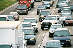
A recent report released by RTMC said that traffic congestion on Twin Cities freeways dropped in 2004 and 2005.Photo by David Gonzalez |
Twin Cities metro area traffic congestion decreased last year, and could decrease again next year.
That good news comes from the Metro Freeway System 2005 Congestion report produced by the Freeway Operations Section of Mn/DOT’s Office of Traffic, Security and Operations, said Nick Thompson, Regional Transportation Management Center operations manager.
The report, released this month, analyzes traffic data RTMC collected from 648 miles of the Twin Cities metro freeway system. The report said that congestion, which had been increasing incrementally during the prior four years, had dropped in 2004, and again in 2005.
The completion of a number of significant road projects aided greatly in this two-year reduction. Some of that work includes:
-
Implementation of the MnPass 394 Express Lanes, which opened on Interstate 394 in May 2005
-
Expansion of Hwy 100 north of I-394 from four to six lanes
-
Expansion of I-94 from Brooklyn Boulevard to I-494 from four to six lanes
-
Expansion of I-494 from Minnesota 212 to France Avenue from four to six lanes
However, congestion is not going away, Thompson said. The number of congested miles has stayed at 21 percent during the last couple of years, and based on current funding scenarios, it will increase during the next 15 years to 41 percent of Twin Cities metro freeway miles.
Twin Cities freeways that are congested include I-694 in the east metro area; I-94 between Minneapolis and Maplewood; I-35W north from Burnsville and south from Mounds View; segments of Hwy 169 and Hwy 100, and I-35E from Hwy 36 to downtown St. Paul.
You can find the 2005 Metro Freeway Congestion Report at www.dot.state.mn.us/trafficeng/otepubl/index.html.
By Kevin Gutknecht
|
back
|
|
Preservation ranks first under new federal fund formula
|
|
|
After many months and much discussion with partners and planning organizations, Mn/DOT is changing its approach to distributing federal funds for state and local projects—including the formula for distributing funds to districts/area transportation partnerships.
The priorities, department officials said, will be highway preservation, safety and mobility—in that order.
Changing the formula will better reflect statewide transportation policies and goals, according to Ed Idzorek, Office of Investment Management.
"The current formula was implemented 10 years ago, in 1996, and was based on system size and usage, not system performance," he said. "There is no safety component and no direct measure of highway and bridge preservation needs."
Idzorek was one of a 19-member team that worked to revise the formula.
The team, which included representatives from cities, counties, the Federal Highway Administration, metropolitan planning organizations and Mn/DOT, went through a 16-month process developing the new formula. Area Transportation Partnerships and stakeholder groups provided formal input. Five potential formulas were then provided to Mn/DOT's Transportation Program Committee for final selection.
The committee ultimately assigned weights to the following performance factors:
-
Preservation (60 percent) – to maintain the state's transportation system
-
Safety (10 percent) – to promote safety needs beyond those already included in every project
-
Mobility (30 percent) – to achieve reliable travel times and address congestion
"There was really tremendous consensus from all parties regarding the choice of the variables,” said Abby McKenzie, director, Office of Investment Management.
"The new formula aligns with Mn/DOT priorities. It distributes funding based on priority performance needs, especially bridge and pavement preservation."
The new formula will become effective in 2009. Funds distributed to the ATPs by the new formula are projected to increase from $330 million per year currently to $392 million per year.
McKenzie said the new distribution method will also help to address "mega” projects that are difficult for a single district to fund.
Such “mega” bridge and corridor projects will be funded in part by two new statewide funds: the Statewide Corridor Fund and the Statewide Bridge Preservation Fund. These statewide funds will be established after distributing formula funds to the ATPs.
Districts will nominate projects to be funded through the corridor fund. Eligible projects must be of statewide significance and cost 50 percent of an ATP’s federal funding allotment. Districts or local partners will need to match the other 50 percent.
Projects selected for the statewide bridge preservation fund, approximately $40 million annually, will receive 100 percent funding for bridge costs, while the district/ATP will pay for the approach costs. Eligible bridges must cost more than 50 percent of an ATP’s annual federal funding.
“In all cases the amount of money allocated to each Area Transportation Partnership increased, and the percentage of share changed in several cases,” said McKenzie. “Because the formula relies so heavily on preservation, the share to the Twin Cities metro area ATP has actually decreased slightly in proportion to Greater Minnesota.”
For details on the revised formula distribution go to: http://www.oim.dot.state.mn.us/targetformula/
By Jeanne Aamodt and Lucy Kender
Area Transportation Partnerships
Federal funds are made available through the federal surface transportation act, SAFETEA-LU. In Minnesota, Area Transportation Partnerships make recommendations related to state and local transportation improvements using federal funds. Each Mn/DOT district/ATP has its own federal target funding. To improve the area's transportation system, projects are ranked and selected annually by each district's ATP.
According to Abby McKenzie, Investment Management director, partnerships improve service delivery, maximize results and minimize duplication or waste of resources. The ATP membership varies in each district. In addition to the Mn/DOT district office, members may include representatives from State Aid cities with a population of 5,000 or greater; counties; tribal communities; regional organizations (regional development commissions, metropolitan planning organizations, etc.); and transportation modal interests (transit, air, rail, freight, shipping, bikes, pedestrian).
Minnesota’s eight ATP boundaries are quite similar, but do not mirror Mn/DOT district boundaries. ATP boundaries are based on county lines, whereas the Mn/DOT districts are based on historic maintenance area boundaries.
|
|
back
|
|
Arnebeck appointed director of Operations, Safety and Technology Division |
|
|
Rick Arnebeck has been appointed to direct the Operations, Safety and Technology Division, Lt. Gov./Commissioner Carol Molnau announced March 14.
Arnebeck, who has served as director of the Office of Maintenance since November, succeeds Marthand Nookala, who left Mn/DOT in January for a position with Hennepin County. Arnebeck also will serve as acting state maintenance engineer until his replacement is named.
In his new role, Arnebeck will provide leadership and technical direction for the offices of Electronic Communications, Homeland Security, Information Technology, Maintenance, Traffic, Security and Operations, and Transportation Data and Analysis. In addition, he will work closely with local, national and international organizations to continue developing partnerships that will enhance Minnesota’s transportation system.
Arnebeck’s career with Mn/DOT started in 1974. His many positions include serving as a construction project manager with the Metro District and as an area maintenance engineer in St. Cloud with Baxter/District 3. He also led development of Mn/DOT’s activity-based cost management and budgeting process.
In addition to his service with Mn/DOT, Arnebeck served as the Winona County engineer from 1984 to 1992.
Arnebeck holds a bachelor’s degree in civil engineering and a master’s degree in the management of technology from the University of Minnesota.
His office is in Room 427 of the Transportation Building; he can be reached at 651/296-1615.
|
back
|
|
Governor delivers State of the State address |
|
|
Highlighting some of the major accomplishments of his administration during the past three years, including implementing the state’s largest transportation funding package, Gov. Tim Pawlenty presented his annual State of the State address to legislators on March 9.
During his 41-minute address, the governor focused on four areas key to Minnesota ’s future: education, health care, natural resources and job growth.
“In a changing world, our future success depends on our ability to innovate,” the governor said. “That’s great news, because innovation is what Minnesota does best.”
In the transportation area, the governor cited implementing the state’s largest-ever transportation funding package and providing funding for the Northstar Commuter Rail line from Big Lake to Minneapolis as two of the administration’s major accomplishments.
Go to the governor’s Web site to read the text of the State of the State address or listen to the audio presentation.
|
back
|
|
Documentation of state’s historic waysides earns honors |
|
|
 |
|
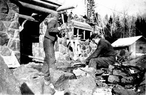
Stone masons working for the Civilian Conservation Corps prepare stones for use while building a concourse at the Gooseberry Falls along Lake Superior north of Duluth on Hwy 61. (The site is now part of a state park and a Mn/DOT rest area.) Photographs courtesy of the Department of Natural Resources’ Hughes and Prudhomme Collection |
Chances are you have seen or stopped at some of Minnesota’s most historic highway waysides.
There is, for example, the stone concourse that reaches 180 feet into scenic Lake Mille Lacs along Hwy 169 in Garrison.
Or the soaring stone obelisk marking the site of Camp Release near Montevideo where 269 white settlers, held captive during the Indian Uprising of the 1860s, were set free in 1862.
Chances are also very good that you’ve sped by many others that are in such poor condition they’re barely noticeable.
An article describing Mn/DOT’s preservation efforts toward these and other historic roadside facilities earned the annual Gephard Award from the Society of Architectural Historians’ Minnesota chapter.
The article, written for the National Park Service’s Currents, highlights Mn/DOT’s preservation efforts that were initiated to identify a property’s historic significance early in project development, streamline cultural resource reviews and improve planning and maintenance decisions.
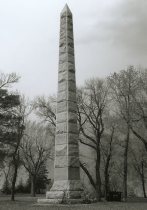 |
The Camp Release monument, a stone obelisk 50 feet high near Montevideo , marks the location where white settlers held captive during the Indian Uprising were freed in 1862. The Chippewa County landmark was erected in 1899. |
Liz Walton, a landscape architect with Environmental Services, will accept the award for Mn/DOT in Minneapolis on March 22.
Walton, Rolf Anderson, a consultant, and a historical consulting firm co-wrote the article, which also describes how Mn/DOT’s research began as a simple inventory and evolved to a more comprehensive undertaking that led to development of comprehensive planning and investment tools for its statewide roadside development collection.
Mn/DOT’s waysides vary widely in size and complexity. They may contain historical markers, geological markers and/or picnic tables. Most were built in the 1930s and early 1940s as public works projects during the Great Depression.
The facilities resulted from highway planning that incorporated sound engineering practices and increased safety with landscaping and roadside facilities, Walton said.
The waysides were designed as safe havens for travelers and were often developed in areas rich with history or along highways located in some of the most picturesque parts of the state.
“The waysides are a transportation legacy,” Walton said. “They were built to ensure a safe, interesting and pleasant traveling experience.”
|
back
|
|
|
|