Newsline
Aug. 11, 2010
Newsline Home Newsline Archives Print Newsline Submit News Feedback About Newsline iHub Home mndot.gov Web site

Table of Contents

NEWSLINE HOME

Print Newsline
SELECT ALL or Click checkboxes below to select articles you wish to print.
Use your browser's Refresh Button to deselect all.
TABLE of CONTENTS

Wakota Bridge dedication brings sigh of relief

By Donna Lindberg & Angela Mathis

bridge

Both the eastbound and westbound lanes of the Interstate 494 Wakota Bridge over the Mississippi River are now open to traffic. Photo by David Gonzalez

The Interstate 494 Wakota Bridge, a project spanning 466 feet over the Mississippi River and eight years of construction, was dedicated at a ceremony in South St. Paul July 29.

Commissioner Tom Sorel spoke at the dedication about the new bridge being a strong testament to the hard work of the Wakota Bridge Coalition and local partners to maximize resources and provide benefits to the region and state. Members of the coalition were also on hand to thank the public and local businesses for their patience.

Construction of the westbound bridge began in 2002 and was completed in 2006. Due to a design error, construction of the eastbound bridge was delayed until 2008. 

“The decision to redesign the eastbound bridge and retrofit the westbound bridge after cracks appeared was a difficult one, but I believe the right one,” Sorel said. “Mn/DOT has taken the lessons learned from the Wakota Bridge and applied them to the other bridges being built around the state.” 

Tom Sorel

Commissioner Tom Sorel speaks at the Wakota Bridge dedication about the collaborative efforts of those involved in the project. Photo by Nick Carpenter

The new Wakota Bridge features five traffic lanes in each direction—compared to the old bridge, which had two lanes in each direction, no sidewalks and narrow shoulders.

The project also included local road improvements, construction of two pedestrian/bicycle overpasses and trails. In addition, I-494 in the east Twin Cities Metro area will soon provide a reconstructed corridor from the airport all the way to I-94 that will accommodate projected future traffic capacity.

“This bridge will reduce congestion in this corridor and serve the public well for a long time,” Sorel said. “It should enhance the quality of life for all those who travel the bridge every day.”

For more information about the Wakota Bridge project, visit http://www.dot.state.mn.us/metro/projects/wakota/index.html.

Headlines TABLE of CONTENTS

Smart Lanes offer innovative approach to traffic management

smart lanes

Mn/DOT's Smart Lanes system went live July 29 on Interstate 35W between Bloomington and Burnsville. Photo by David Gonzalez

Motorists traveling on Interstate 35W between Bloomington and Burnsville have received electronic driving recommendations through digital signs that illuminate during traffic incidents or when weather and road conditions warrant slower speeds. The real-time “Smart Lanes” system, which was turned on July 29, is the first of its kind in the nation.

The digital signs alert drivers about the road conditions within their lane, what is up ahead and what the recommended speed is at that moment. The signs also indicate which lanes are open or closed to traffic.

“It appears that people are following the posted speeds, slowing down and paying closer attention to the road,” said Brian Kary, freeway operations engineer at the Regional Transportation Management Center.

The variable speed limits are fully automated and loop detectors in the pavement measure average speeds of vehicles, according to Kary. Based on the average speed, advisory speed limits are then posted upstream on the digital signs.

The easy-to-understand digital signs are posted every half mile and cover all lanes on both directions of the 10-mile section of freeway. The new signs are part of the Urban Partnership Agreement between state and federal governments that aims to reduce congestion on I-35W.

Last year, Mn/DOT installed the structures and digital signs over the lanes and has been using the signs since Sept. 30 to post a red “X” when a lane is closed due to a traffic crash, a yellow arrow to indicate motorists should merge and a diamond to designate the MnPASS Express Lanes. Operators at the RTMC deploy the “Xs” or arrows. The latest component of advisory speed limits has been used successfully in Europe to manage traffic congestion and reduce crashes on busy roads.

“This is the next generation of real-time information for motorists,” said Scott McBride, Metro District Engineer. “The technology saves money by allowing us to better use existing road space, while improving safety and creating more reliable travel times.”

Mn/DOT first used electronic signs to inform motorists of road conditions when it installed signs near the Lowry Hill tunnel in Minneapolis many years ago. More Smart Lanes will open on I-94 between St. Paul and Minneapolis by fall 2011.

For more information on Smart Lanes, visit http://www.dot.state.mn.us/smartlanes.

Headlines TABLE of CONTENTS

FIRST driver rescues mom, kids from pond

By Angela Mathis

video link

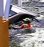
Video of Don Machacek rescuing a mother and her two kids from a submerged vehicle on July 28. Video courtesy of Regional Transportation Management Center

Don Machacek, Freeway Incident Response Safety Team, recently rescued a mother and her two children from a car that had veered off Interstate 35W and plunged into a pond just south of 76th Street in Richfield. The incident happened July 28.

Machacek was a few miles north of the incident when he heard the call go out over the radio. Machacek then advised dispatch he was en route and arrived within minutes.

As he drove to the scene, Machacek said he remembers thinking, “It’s not going to be that bad.” He had responded once to a similar call and the water had not been deep. But then he followed the tire tracks, climbed over two fences and saw the car in neck-deep water.

“It was a little worse than the previous incident. I began wondering about the condition of the people in the vehicle—maybe they drove off the road because the driver had a heart attack,” Machacek said. “Someone could have been injured in the crash—I didn’t know.

“When I saw three sets of eyes looking at me from the back window of the car, I took out my hand-held radio and said, ‘I’m going in.’”

Machacek went into the water, opened the car door and helped the family to safety. None of them were injured.

“Machacek’s actions were heroic—he did what needed to be done without hesitation,” said John Lardy, Machacek’s FIRST supervisor. “Still, it probably wasn’t the most dangerous thing he’s done—changing tires and working with traffic at freeway speeds is just as dangerous, if not even more so.”

In their more than 15,000 stops a year, FIRST drivers typically assist the Minnesota State Patrol, move broken-down or crashed vehicles and debris out of traffic, make minor vehicle repairs, help with traffic control, change tires, call tow trucks and supply gas, according to Lardy.

FIRST driver

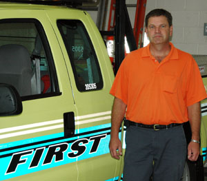
Don Machacek, Freeway Incident Response Safety Team, has worked as a FIRST driver for more than four years. Photo by Nick Carpenter

“We get calls for anything that affects traffic,” Lardy said. “Whenever you think you’ve seen it all, something new comes up.”

Machacek has worked as a FIRST driver for more than four years.

“I really like helping people,” Machacek said. “The smile, thanks and appreciation you get from changing a tire or calling a tow truck—it feels good.”

Rescuing the family from the partially submerged car was also “just part of the job,” according to Machacek.

“I’d have done the same thing if I had seen it from my own car,” Machacek said. “To me, it’s not that big of a deal, but my kids, family and dad are so proud.

“I was cutting the grass the other day and several neighbors came over to talk to me about it. It’s been kind of overwhelming.”

For more information about the FIRST program, visit http://www.dot.state.mn.us/rtmc/first/index.html.
Headlines TABLE of CONTENTS

New law: Complete streets policy addresses needs of all commuters

By Erik Rudeen, Government Affairs

Legislation enacted this year requires Mn/DOT to implement a complete streets policy for state roadways that addresses the needs of motorists, pedestrians, transit users, bicyclists and commercial and emergency vehicles.

The legislation defines complete streets as “the planning, scoping, design, implementation, operation, and maintenance of roads in order to reasonably address the safety and accessibility needs of users of all ages and abilities.” The law encourages transportation authorities to be sensitive to local context and recognizes that transportation needs vary in urban, suburban and rural settings.

Mn/DOT is required to implement a complete streets policy after consultation with stakeholders, state and regional agencies, local governments and road authorities. In developing the policy, the department must address relevant protocols, guidance, standards, requirements and training, as well as integrate related principles of context-sensitive solutions.

Under the direction of Julie Skallman, State Aid Division director, an external advisory group will advise the agency on implementing the policy and discuss complete streets efforts at the local level.

Beginning next year, Mn/DOT must report on the implementation of the policy in the agency's biennial budget submission. In addition, reports to the Legislature are required in 2011, 2012 and 2014 that summarize the department’s complete streets initiatives and identify any statutory barriers to complete streets implementation.

For a summary of the 2010 legislative session, visit http://ihub.dot.state.mn.us/governmentaffairs/legislative2010/finalsummary/2010yearend.pdf.

This is the fifth installment in a short series of 2010 Legislative Session highlights.
Previous highlights:

Business TABLE of CONTENTS

District 3 employee eligible for vacation donation

Robb Mattson

Robb Mattson, District 3-Buffalo Truck Station, has worked for Mn/DOT more than 15 years. Photo courtesy of District 3

Robb Mattson, District 3-Buffalo Truck Station, has been approved for the state vacation donation program, which allows employees to donate up to 40 hours of vacation per fiscal year for approved recipients who have exhausted their sick and vacation leave due to illness.

Mattson was recently diagnosed with Acute Myelogenous Leukemia and is currently undergoing chemotherapy. He will eventually require a bone marrow transplant.

To donate vacation hours, go to the Employee Self Service Web site and click “Other Payroll” and then “Leave Donations.” The site also allows employees to view a list of all state employees eligible for the program and enroll as a recipient.

Related information:

Vacation donation: a worthy program for worthy people (Newsline, June 21, 2006)—Read a viewpoint from one Mn/DOT recipient.

Business TABLE of CONTENTS

Mn/DOT gears up for State Fair

By Lisa Yang

display

Mn/DOT is continuing its presence this year at the Minnesota State Fair, which runs from Aug. 26 - Sept. 6.

This year’s theme is “Your Destination…Our Priority.”

“The fair is one of our most effective tools for communicating with our customers,” said Khani Sahebjam, deputy commissioner and chief engineer.

The Mn/DOT booth will feature a display with information that will focus on:

  • Roundabouts, zipper merge and Smart Lanes
  • 511mn.org – how to use it
  • Transportation funding
  • Finding transit options in the state

The exhibit will be located in the Education Building at 1372 Cosgrove Street (north of Dan Patch Avenue).

For more information about Mn/DOT at the fair or to sign up to work at the fair, visit http://ihub/statefair.

Discounted state fair tickets available through Hiwayan Club

Discount tickets are now on sale until the end of August. You must be a Hiwayan Club member to purchase tickets at the discounted price.

For more information, visit http://ihub.dot.state.mn.us/hiwayan/events.html.

Business TABLE of CONTENTS

New Library Materials posted on Web

By Qin Tang

The July 2010 edition of New Library Materials is now available at http://www.dot.state.mn.us/library/newlibmat.html.

Included in this issue is information about the ASCE Civil Engineering Database that provides access to more than 170,000 bibliographic records of all ASCE publications. Employees have access to articles in all ASCE journals.

New Library Materials is a compilation of new titles and other resources added to the library collection during the previous month. If you would like to be added to the distribution list, please contact Pam Gonzalez at 651-366-3749.  

For other information requests, contact the library at 651-366-3791 or e-mail library.dot@state.mn.us. Employees can also send requests via the “Ask a Librarian” Web page at http://ihub.library/asklibrarian.html or http://www.dot.state.mn.us/library/asklibrarian.html.

Variety TABLE of CONTENTS

Reconstruction of Hwy 11 results in 126-mile detour

By Beth Petrowske

Hwy 11

Hwy 11 remains closed to traffic as crews reconstruct the section of highway between Baudette and Pelland near the Canadian border. Photo by Peter Leete

Hey, did you hear the joke about the 126-mile detour?

The truth is it’s not a joke—at least not to the folks involved with the Hwy 11 reconstruction project in District 2.

“There is nothing funny about a 126-mile detour,” according to Karen Bedeau, District 2 public affairs coordinator.

The detour, quite possibly the longest in Mn/DOT history, is necessary as crews work to reconstruct Hwy 11 near the Canadian border.

link to map

Motorists traveling the 126-mile detour can expect to add 2 hours and 41 minutes to their drive time, according to MapQuest estimates.

Hwy 11 serves as a major transportation corridor for locals, truckers and tourists visiting area resorts and lakes. It would seem that closing such an important route for three months would generate many complaints, but complaints related to this project are almost non-existent, according to Jeremy Hadrava, project engineer. People want to see the road improved, even if it means having a 126-mile detour to do it.

“There just aren’t any other options for a shorter detour—the area is surrounded by one great big bog and there aren’t many roads,” Hadrava said. “In spite of the inconvenience, the local people are really happy to get the project done.”

Canada’s Hwy 11 is located on the other side of the international boundary and runs almost parallel to Minnesota’s Hwy 11. Hadrava met with Canadian highway authorities to discuss the possibility of using Canada’s Hwy 11 as a detour route, but homeland security concerns prevented it as an option.

A detour could have been avoided altogether if the project was staged over a two-year period, but local residents supported the plan to complete the reconstruction in one year and endure the detour, according to Hadrava.

Access to homes and businesses on Hwy 11 has been and will continue to be maintained during the project. However, there are times that access may be delayed. Flaggers are posted at both ends of the highway and are able to provide residents with details about what to expect in terms of delays.

When the project is finished in November, Hwy 11 will not only be safer and smoother, the pavement should remain in good condition for about 15–20 years, according to Hadrava. This project marks the first time since 1937 that this section of Hwy 11 has undergone major grading work.

“Considering that about 75 percent of the traffic on Hwy 11 is from heavy commercial vehicles, Hwy 11 has lasted long past its design life and the reconstruction is much needed," Hadrava said.

Planning a detour

Mike Engh, Metro District senior engineering specialist, recently explained some of the things that all Mn/DOT traffic engineers must consider when planning a detour route:

Comparable road alternatives—Detour routes should be placed on Mn/DOT-controlled roads similar to the road being closed whenever possible. If a comparable road is not available, other roads may be used, but may need to be improved to handle additional traffic. Improvements include additional signing and pavement markings.

Weight restrictions—The closed route and the detour route should be rated similarly in regards to weight restrictions.

Other road projects—The detour route should not conflict with city or county road projects.

Emergency routes—Detour routes should be planned so that emergency responders can get to hospitals and respond to other emergencies.

Events—Proposed detour routes should be examined by Mn/DOT traffic engineers and local authorities as to avoid interference with city events or major sporting events.

Bicycle and pedestrian routes—Detour routes should be designed to address the needs of bicycle and pedestrian traffic, especially in urban areas.

 
SELECT ALL or Click checkboxes above to select articles you wish to print.
Use your browser's Refresh Button to deselect all.

  TABLE of CONTENTS

NEWSLINE HOME