|
|
|
|
 |
TABLE of CONTENTS
|
MnDOT launches work zone safety public education campaign |
By Chris Krueger

As part of the Work Zone Awareness public education campaign, billboards are posted around the state. The billboards remind motorists to slow down and pay attention in construction zones. Photo by Rich Kemp
|
Despite the wintry weather Minnesota is still experiencing, MnDOT kicked off national Work Zone Awareness Week (April 15-19) with a new public education campaign that reminds motorists to slow down and pay attention in construction zones.
“Work zones are dangerous places for workers and travelers,” said Commissioner Charlie Zelle. “This campaign is one of many ways we are reminding people to drive safely when they see orange barrels and trucks.”
The billboards, radio, television and online advertising coincide with state road crews starting construction on more than 300 projects across Minnesota. City, county and tribal governments also are working on multiple highway improvement projects. The ads will run through November.
Two of the most common factors in work zone crashes are speeding and inattentive driving. The ads are designed to remind motorists of their responsibility to keep themselves and workers safe.
In 2012, there were 1,931 total crashes in Minnesota work zones—three individuals were killed. The three-year average for work zone crashes is 1,819 crashes and seven fatalities per year.
Promoting work zone safety is a component of the state’s core traffic safety initiative, Toward Zero Deaths. A primary vision of the TZD program is one in which motorists support a goal of zero road fatalities by practicing and promoting safe and smart driving behavior. TZD focuses on the application of four strategic areas to reduce crashes — education, enforcement, engineering and emergency trauma response.
Stay safe in work zones
- Work zones are wherever you see workers, flaggers and surveyors in bright yellow-green or orange vests.
- Work zones also include stopped emergency and highway maintenance vehicles with flashing lights.
- Work zones are also marked with orange cones or barrels, concrete barriers, traffic control devices or moving vehicles with flashers.
- Work zones operate day and night, anywhere you travel.
Pay attention
- Stay alert, especially at night.
- Obey posted speed limits. Fines may double for violations in work zones.
- Expect work zones to constantly change. Day to day, you could experience lane shifts, closures or moving workers and vehicles.
- Never enter a road blocked with barriers or cones.
- Don’t make unnecessary lane changes.
- Stay off cell phones and mobile devices.
- Be patient. Expect delays, especially during peak travel times.
- Move over one lane, if possible, or reduce speed for stopped emergency or maintenance vehicles, including ambulance, fire, law enforcement or maintenance and construction vehicles.
|
|
|
|
|
|
TABLE of CONTENTS
|
Districts, CO to observe Workers Memorial Day April 29 |
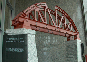
A Worker Memorial, which lists the employees and contractors who have died on transportation projects, is located in the lobby of the Transportation Building in St. Paul. Photo by Rich Kemp |
MnDOT will commemorate Workers Memorial Day Monday, April 29, with several events statewide to honor the fallen workers who died while working on state construction and maintenance projects.
The agency’s statewide observance will be highlighted by 10 seconds of silence at 2 p.m.
Other events include:
- 8 a.m. – District 6/Rochester maintenance facility
- 9 a.m. – Metro District, Waters Edge
- Noon – District 7/Mankato motor pool
Since 1960, 33 MnDOT employees and 15 private sector contractors have lost their lives while working on Minnesota highways. The last MnDOT employee who died on the job was Mike Struck, who worked in District 7/Mankato Maintenance. Struck drowned March 22, 2011 near St. Peter when the backhoe he was using to clear debris from the Minnesota River was pulled into the water.
Governor Mark Dayton has proclaimed April 28, 2013 as Workers’ Memorial Day. Since 1989, April 28 has been recognized nationally and locally as a day of remembrance of workers who have been injured or killed on the job. Since the official day falls on a weekend this year, MnDOT has chosen its observance for the closest weekday, April 29. |
|
|
|
|
|
TABLE of CONTENTS
|
Project highlight: Diamond interchange in Maplewood to improve safety on Hwy 36 corridor |
|
By Denise Workcuff, Metro District public affairs coordinator
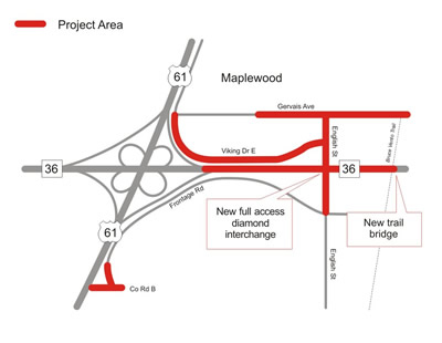
The Hwy 36/English Street project will result in various safety and bike/pedestrian improvements, while promoting corridor’s overall efficiency when completed later this year.
|
One more Hwy 36 intersection controlled by a traffic signal is soon to be history.
By late November, the project to turn the Hwy 36/English Street intersection in Maplewood into a full access diamond interchange will be substantially complete. It is the sole signalized intersection on this corridor between Hwy 120 and Interstate 35W.
The $17 million project will include a full suite of advantages and benefits for motorists and bike and pedestrian users.
In addition to making the corridor itself more efficient and improving safety, the project also includes improving the Ramsey County Road B/Hwy 61 intersection, improving safety by removing existing access to Hwy 36 at Hazelwood and Atlantic Streets and replacing the Vento Trail pedestrian and bicycle bridge.
Construction of retaining walls for Hwy 36 started in March and will extend into June, and earlier this month County Road B and the Cope Avenue Frontage Road construction began. Completion of that phase should wrap up in mid-May.
Between now and mid-June, the Bruce Vento Trail bridge will be built, and the existing path realigned. (A short-term closure of the trail is scheduled as the new bridge is aligned, and during the same timeframe the County Road B Trail will be constructed).
A two–month closure of both directions of Hwy 36 between Hwy 61 and Hazelwood Street begins in mid-June while the Hwy 36/Hwy 61 ramps and Hwy 36/English Street ramps are constructed.
For more information, visit the project web site. |
|
|
|
|
|
|
|
 |
TABLE of CONTENTS
|
Cassandra Isackson selected as Aeronautics director |

Cassandra Isackson will start as the Aeronautics director effective April 24. Photo by David Gonzalez |
Cassandra Isackson has been selected as the director of the Office of Aeronautics, effective Wednesday, April 24.
Isackson has worked for MnDOT for 15 years, most recently as the director of the Office of Transportation Data and Analysis. Prior to leading TDA, she served in various roles throughout MnDOT, including positions in the Office of Traffic, Safety and Technology, in the Metro District’s Traffic Office, in the Office of Project Management and Technical Support, and in Materials and Road Research.
“Cassandra brings charisma, commitment, competence, focus and initiative to the job of directing and overseeing the Minnesota system of airports and general aviation services,” said Tim Henkel, MnDOT assistant commissioner. “These attributes combined with the depth and breadth of her professional experience will ensure the continued promotion of aeronautics in Minnesota and the successful implementation of the Aviation Services Program.”
Isackson began her career working for the Alabama Department of Transportation. She received her Bachelor of Science degree in Civil Engineering from the University of Alabama. She is a registered professional engineer in the state of Minnesota.
Isackson will be moving to the Aeronautics building at 222 East Plato Blvd in St. Paul.
For more information on MnDOT Office of Aeronautics, go to www.dot.state.mn.us/aero/. |
|
|
|
|
|
TABLE of CONTENTS
|
Library asks for your assistance with survey |

Jim Byerly, reference librarian, Sheila Hatchel, library director and Marilee Tuite, assistant librarian, discuss the customer survey that was sent out to MnDOT employees on April 16. Photo by Rich Kemp |
The MnDOT library is conducting a customer survey to assist with future planning. The survey was sent out to all MnDOT employees through NoteMailer on April 16.
“We are trying to find out what we are doing well and where we can make improvements,” said Sheila Hatchel, MnDOT Library director. “We really appreciate everyone taking 5-10 minutes out of their busy day to assist us with this survey.”
The survey has been designed so that all answers are anonymous. The survey will be open until April 26 and is available at Library Survey.
The library survey is an important component of a larger library evaluation. A report will be made available when the project is completed.
If you have questions about the survey, contact Hatchell at Sheila.hatchell@state.mn.us or 651-366-3733. |
|
|
|
|
|
TABLE of CONTENTS
|
What's new on the web? |
SharePoint
MnDOT is preparing to offer Microsoft SharePoint 2010 as a service this year. SharePoint makes it easier for people to work together. Using SharePoint, you can set up websites to share information with others, manage documents, publish reports, and to utilize project planning tools to help you work more efficiently. Visit ihub/sharepoint/ for videos about how to use SharePoint and the latest news on when it will be available.
Transportation Economic Development
Learn more about TED, the roadway to job creation, which provides funding for state and local transportation infrastructure improvements to encourage the growth of new or existing businesses. The 2013 TED application, seeking eligible new projects, is now available at www.dot.state.mn.us/funding/ted.html.
New library materials on the Web
The March 2013 edition of New Library Materials is now available at http://www.dot.state.mn.us/library/newlibmat.html.
Check out this issue to more about the Library Open House on Wednesday, May 8 from 11 a.m. to 2 p.m. New Library Materials is a compilation of new titles and other resources added to the library collection during the previous month. If you would like to be added to our distribution list, please contact Pam Gonzalez [Pamela.M.Gonzalez@state.mn.us]at 651-366-3749.
|
|
|
|
|
 |
TABLE of CONTENTS
|
On the Job: Mike Stangler helps MnDOT stay balanced |
By Bob Filipczak
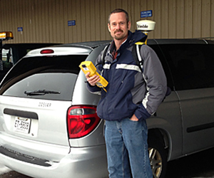
Mike Stangler, District 3/St. Clouds environmental coordinator, works on delineation of the wetlands to determine the amount of impact and apply for permits before the construction begins. Photo by Bob Filipczak |
When it comes to wetlands, mussels, eagles, turtles and fishery resources in central Minnesota, MnDOT relies on Mike Stangler, District 3/St. Cloud’s environmental coordinator, to help plan projects that have the least impact on Mother Nature. His specialty is wetlands, and he works as part of the planning team to make sure state roads balance engineering requirements with their effect on the surrounding environment.
So, you’re part of the planning office?
I step into the process when they create the National Environmental Policy Act document for a project. This happens early in the project development phase.
The NEPA document takes a look at the social, economic and environmental impacts of a project.
Some of the documents are really extensive. In the case of the Hwy 23 project from St. Cloud to Foley, I came in when we were just in the planning stages. I took a GPS unit and inventoried all of the wetlands along that 300-foot wide corridor for seven or eight miles—the whole corridor. Then we knew where we wanted to place the road.
Then I’ll come in and create three or four pages of that NEPA document that says, “Ok, if we are going to go with this alignment, we are going to have 18.2 acres of impact to these different types of wetlands.” The goal here is to indicate that we have done the best we can to avoid wetland impacts, without compromising the safety of the traveling public.
I also go through and do a functional assessment of the wetlands. I will report that wetlands in the corridor provide flood storage, nutrient assimilation—like a sediment pond—and they provide wildlife habitat and ground water recharge, among other functions.
Then we work with the Board of Water and Soil Resources to replace any of the wetlands we impact. This is all arranged very early in the project development process.
We create wetlands?
Actually, we work with the Board of Water and Soil Resources. They go out and create wetlands. We usually replace wetlands at a 2-to-1 ratio or a 1.5-to-one ratio. So when we need credits, we will tell them we need 40 acres of credits for a particular project and want it located as close as possible to this corridor. We also say we need it replaced in-kind if possible (meaning the wetland type that was impacted will be replaced with the same wetland type in the mitigation site).
How do they create wetlands?
The Board of Soil and Water Resources has networks. For example, they will work with the private landowners to restore upland areas back to wetland, which often involves plugging a ditch or severing a tile line. At that point the site is often seeded with native wetland plant species.
Often the Board will already have some wetland credits established and they will provide them to us for a nearby project.
When is your busiest part of the year?
My busiest time of the year is right now. It’s time I need to get a more detailed delineation of the wetlands done so we can determine the amount of impact and apply for permits before the construction season begins.
For example, we will have some special funding come along through some legislation, and we need to get the project done in a certain timeframe to take advantage of the funding. Mid-April is typically when I can get a soil auger in the ground, and I need to get out there and get it done as soon as possible. Wetland delineations take a long time. Even with a small corridor, there may be six wetlands, and I can usually get two or three delineations done a day.
Wetland delineations typically involve looking at the soils, water tables and vegetation to document specific observations that indicate the edge of the wetland.
Even for the simplest permit, the Army Corp of Engineers wants 60 days to make a decision. So you are looking at three to four months minimum turnaround time. Some of these projects are on a fast track and the project engineer wants to let it in July. So they are telling me, “Mike we need to get this done,” and I’m out there by April 15 or as soon as I can get a soil auger in the ground.
And then what happens?
After delineations are done, the information is downloaded onto the computer from the GPS unit, wetland impact exhibits are created, and the permit application is filled out and submitted to the Army Corps of Engineers.
Is there any follow-up or are you done?
There is a little bit of follow-up work. For example, with the Hwy 23 corridor, I had to go out there several times just to look at the Elk River because the DNR requested redundant erosion control. Because we have ‘special concern’—not threatened or endangered—mussels, I had to run out there and just say: How are we doing? How is the silt fence looking? because the DNR will be out here once or twice this year for sure to look at the project.
So there is a little bit of follow-up. At times we have had to monitor the noise and the human activity around eagles’ nests to verify that nesting activity wasn’t disrupted.
I also monitor wetland mitigation sites that MnDOT created several years ago, before we had access to the mitigation sites established by the Board of Water and Soil Resources. These sites are monitored to make sure they are functioning as they were intended, providing flood storage, nutrient filtration and wildlife habitat.
Do you monitor any other animals?
We do have to watch out for Blanding’s turtles. The DNR will tell us if there are substantial numbers of Blanding’s turtles in the area. If that’s the situation, we may be asked by the DNR to install fencing to keep the turtles out of the construction area. |
|
|
|
|
|
|
|
|
| |
|