|
|
|
|
 |
TABLE of CONTENTS
|
Hwy 169 project raises road elevation above pesky Minnesota River floodwaters |
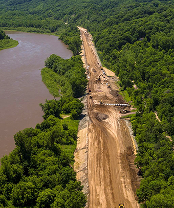
Crews raised road elevations of Hwy 169 from St. Peter to Mankato to maintain traffic flow during high water. The project is expected to be completed in October. Photo by Joe Smithers |
The Minnesota River meanders serenely through the fields and woods of southwestern Minnesota, most of the time. Occasionally and with increasing frequency, the river leaves its banks, destroying property, disrupting traffic, and once, in 2010, taking the life of a Maintenance worker trying to clear a plugged box culvert.
In response to the problem of increased flooding, District 7 is about to complete its third project in three years to raise road elevations above the Minnesota River 100-year flood elevation. This latest project, situated on Hwy 169 between sandstone bluffs and the river channel, proved the most challenging of the three. The $30 million project included three miles of grade raise and paving, six miles of concrete overlay, drainage work and the addition of concrete and high tension cable median barriers.
“There was pressure to do the work half at a time and keep the road open,” said Peter Harff, project manager. “But that would have increased construction costs by millions of dollars, required two years to build it and been much less safe.”
Safety was the driving factor in the decision making, leading MnDOT to invest in intersection improvements on parallel routes Hwy 22 and the official detour on Nicollet County State Aid Hwy 13 in 2015.
“We took 17,000 vehicles per day off the four lane Hwy 169 and had to send them on two lane roads,” said Scott Thompson, District 7 traffic engineer. “Hwy 22 was already carrying 12,700 vehicles per day before closing Hwy 169 and that shot up to 18,000 vehicles per day. In the four months the traffic was detoured, there were no injury crashes. We have the intersection improvements, good traffic control, the public information campaign and our traffic calming friends at State Patrol to thank for that.”
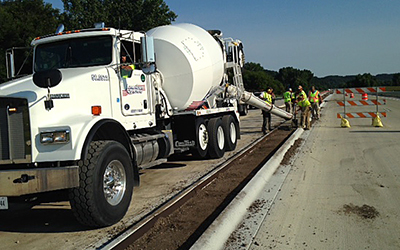
The Hwy 169 construction crew pours concrete on a stretch of the road between St. Peter and Mankato. Photo by Peter Harff |
Recognizing that many of the problems on detours occur in the first week as traffic adjusts to a new routine, District 7 conducted a social media campaign based on short videos to inform drivers throughout the region of the upcoming detour.
“Not everyone who drives Hwy 169 reads the local paper, so we took the message to where people are…on their smartphones,” said Rebecca Arndt, District 7 public affairs coordinator. “More than 2,000 people receive regular email updates on the progress.”
“Preparation is an important part of a successful project, but with the very wet summer, success on this one was dependent on an effective MnDOT/contractor partnership,” said Susan Museus, project supervisor.
In addition to rain that caused mudslides and failed inslopes, there were poor river bottom soils, drainage issues and extra coordination to align concrete overlay pavement with paved medians.
Partnership was important in getting the project off the ground. Originally envisioned as a pavement preservation project with little flood mitigation, the Region 9 Regional Development Commission worked with MnDOT to submit an application for a grant from the federal Economic Development Administration. The EDA provided $9.8 million in the interest of keeping commerce flowing even as the river is flooding. The EDA is expected to join District 7 for a celebration when the project is completed in mid-October.
|
|
|
|
|
|
TABLE of CONTENTS
|
Tractor mowers are equipped with automated vehicle location systems |
In this video a MnDOT research project equipped more than 40 tractors with automated vehicle location systems, developed an in-cab touchscreen map and created an automated reporting system for mowing operators and supervisors. The AVLs also help the mower operator track noxious weeds and avoid areas where they are prominent. Video procuced by Micheal Foley, Research Services |
|
|
|
|
|
|
|
|
|
TABLE of CONTENTS
|
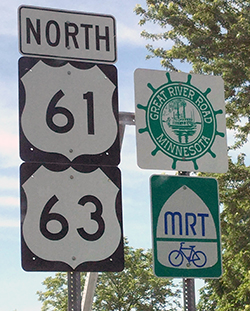
September is designated as the month to celebrate Minnesotas Great River Road |
By Judy Jacobs
Minnesotas Great River Road stretches 565 miles and includes federal interstates, state, county and local roads. Photo courtesy of the Office of Environmental Stewardship |
On Aug. 11, Gov. Mark Dayton issued a proclamation that September would be designated as “Drive the Great River Road Month” in all 10 of the Mississippi River states from Lake Itasca to the Gulf of Mexico. In Minnesota, the Great River Road stretches 565 miles and includes federal interstates, state, county and local roads. The road features 10 interpretive centers, 20 counties and 43 communities; each with a story of their own to tell.
“It’s become an annual tradition for many people to check out the fall colors in Minnesota,” said Carol Zoff, Great River Road program manager, Office of Environmental Stewardship. “The “Drive the Great River Road” campaign encourages travelers to consider the Mississippi River as their trip destination. By following the Great River Road (the network of roadways that abut the Mississippi River) you not only get to some of the state’s pristine out-of-the-way places, you gain a perspective on Minnesota’s role in the development of the nation.”
This month’s campaign notes several Minnesota locations, including some that are not the usual tourist destinations, but they all tell important stories of the country and state from the Mississippi River bank.
- Federal Dam (Cass County): Did you know that as early as 1866, the Army Corps of Engineers was trying to manage the flow of the Mississippi River to protect shipping and milling interests in Minneapolis and St. Paul? Routinely faced with diminishing flow in the river after July, the millers at St. Anthony Falls and navigation interests turned to Congress and the Corps to build the Headwaters Reservoirs. Federal Dam, just off the Great River Road and beside Lake Winnibigoshish, gets its name from this mammoth engineering feat shortly after the Civil War.
- Forest History Center (Grand Rapids, Itasca County): This Minnesota Historical Society site and Great River Road Interpretive Center is devoted to telling the story of Minnesota’s forests and their role building America from right after the Civil War up through the early 20th century. Now, its exhibits also tell of modern forestry practices and products that help drive today’s economy.
- Savanna Portage State Park (McGregor, Aitkin County): Savanna Portage was a canoe portage used by Native Americans for centuries before being used by European explorers, fur traders, Voyageurs and missionaries of the 18th and 19th centuries to link the Mississippi River waterways of the west with the Great Lakes to the east. It’s on the National Register of Historic Places for having state-level significance in the themes of commerce, exploration/settlement and transportation.
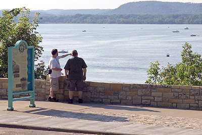
Travelers along the Great River Road enjoy the scenery at Reads Landing Overlook, on Hwy 61, just north of Wabasha. Photo courtesy of the Office of Environmental Stewardship |
- Charles A. Lindbergh Historic Site (Little Falls, Morrison County) Charles Lindbergh’s 1927 flight to Paris from New York launched the American aviation revolution. But his boyhood on the Mississippi River was his first launching pad. A National Historic Landmark, the original Lindbergh home and visitor center chronicles his life and his impact on America.
- Mill City Museum (Minneapolis, Hennepin County): This Minnesota Historical Society site and Great River Road Interpretive Center beside the Mississippi River commemorates the state’s milling history where the world’s largest flour mill once resided. You can see how the fortunes of Minnesota’s agriculture and the Mississippi River were intertwined to build today’s American food industry.
- The Weisman Art Museum University of Minnesota - “Silver River” Exhibit (Frederick R. Weisman Museum, Minneapolis, Hennepin County): Works by a dozen artists chronicle the Mississippi’s role in industrialization of the state and the nation.
- Historic Fort Snelling (Hennepin County): Another Minnesota Historical Society site and Great River Road Interpretive Center, it’s breathtaking in the fall as well as historic. Home to exhibits on early North American exploration, relations with First Nations People, U.S. and Minnesota military history, this National Historic Landmark gets its significance from its promontory atop the intersection of the Minnesota and Mississippi Rivers in the early days of the state.
- Mississippi National River Recreation Area (St. Paul, Ramsey County): The only National Park devoted to the Mississippi River, this 72-mile park incorporates urban and parkland settings along with on-the-water experiences and history and science. Start at the newly remodeled Visitor Center in the Science Museum of Minnesota.
- National Eagle Center (Wabasha, Wabasha County): If you’re a birder or just an admirer of America’s emblematic bird, this is the place for all-things-eagle. Great naturalist explanations and eagle learning programs with an eye to the role of the Mississippi River Valley Flyway.
For more information about Great River Road and how to check out one or more of these special Minnesota places, visit www.mnmississippiriver.com and www.experiencemississippiriver.com. |
|
|
|
|
 |
TABLE of CONTENTS
|
Three plans, one time period to comment |
After more than a year of intense public and stakeholder engagement, technical analysis and internal discussion, MnDOT released three draft plans for public review and comment:
- Statewide Multimodal Transportation Plan: Last updated in 2012, the SMTP is Minnesota’s highest level policy plan for transportation. The plan is for all types of transportation and all transportation partners.
- 20-Year Minnesota State Highway Investment Plan: Last updated in 2013, MnSHIP directs capital investment for Minnesota’s 12,000-mile state highway system over the next 20 years. It is a fiscally constrained plan that identifies investment priorities given current and expected funding of $21 billion between 2018 and 2037.
- Greater Minnesota Transit Investment Plan: Last updated in 2011, the GMTIP provides a 20-year strategic plan for transit in Greater Minnesota and an investment plan to meet 90 percent of public transit demand in Greater Minnesota by 2025.
This video discusses the Statewide Multimodal Transportation Plan, 20-Year Minnesota State Highway Investment Plan and the Greater Minnesota Transit Investment Plan, which open for public review and comment. |
All three plans are required by state statute and help fulfill federal requirements for transportation planning.
MnDOT planners researched more than 20 trends in population, economics, environment, transportation behavior and technology. In particular, these plans address the following key trends: aging infrastructure, an aging and more diverse population, population growth in the Twin Cities and regional centers throughout the state, climate change and new technology and mobility as service.
The plans prioritize preserving the existing transportation system while making strategic capacity and service improvements with a high return on investment for a limited period of time.
All three plans maintain a focus on safety for all transportation users and the communities they travel through. The plans continue MnDOT’s commitment to the Toward Zero Deaths program.
Making Difficult Trade-off Decisions
Minnesota’s transportation system and the state highway system, in particular, are aging. Much of the system was constructed during the build-out of the interstate system between the 1950s and the 1980s and is reaching the end of its service life. It will require increased capital investment and additional maintenance in the years ahead.
The draft MnSHIP directs approximately 69 percent of available revenues for highway capital investment toward maintaining the existing state highway system, giving priority to roads on the National Highway System. Despite this level of investment, the condition of the system will deteriorate over the next 20 years.
“This focus on investing in existing roads and bridges is consistent with what we heard from the public and stakeholders,” said Brad Utecht, investment planning director in the Office of Transportation System Management.
Given the emphasis on maintaining the current system, the draft MnSHIP does not include any investment in congestion relief (mobility) after 2023.
In MnSHIP, needs are defined as either the costs necessary to meet performance-based targets or the costs related to achieving key system goals. In developing MnSHIP, MnDOT planners estimated there will be approximately $21 billion to invest in state highways over the next 20 years (2018-2037), compared to approximately $39 billion in estimated needs. This results in an unmet need of $18 billion.
“MnDOT will not be able to achieve all performance targets for the state highway system over the next 20 years,” said Utecht.
A Stronger Commitment to Accessibility
The plans strengthen MnDOT’s commitment to providing an accessible and useable transportation system for everyone regardless of individual ability. This update to MnSHIP increases the investment in accessible pedestrian infrastructure so that the state highway system will meet substantial compliance standards for ADA within 20 years.
“If we continued to invest in accessible pedestrian infrastructure at the level called for in the 2013 MnSHIP, we wouldn’t have an ADA compliant state highway system in my lifetime,” said Utecht.
The Greater Minnesota Transit Investment Plan also calls for more reliable and frequent service that connects people to key regional destinations.
Responding to Growing Demand for Transit in Greater Minnesota
“The demand for public transit is growing steadily in Greater Minnesota,” said Sara Dunlap, principal planner in the Office of Transit.
The Minnesota Legislature established a target to meet 90 percent of the demand for public transit in Greater Minnesota by 2025. To meet that target, the transit systems in Minnesota will need to provide 40 percent more trips in 2025 than they did in 2015.
As part of the GMTIP, MnDOT developed a service plan to meet the growing demand for public transit. The plan has three main components:
- Implement a baseline span of service that provides a consistent minimum level of transit hours of service and days of the week for communities of similar sizes
- Implement improvements to urban services that increase geographic coverage, peak period frequency and add regional express services
- Implement improvements to rural services that increase geographic coverage and add frequency of regional service to shopping and medical destinations.
The Office of Transit estimates the service plan can be implemented with existing and anticipated funding through 2020. After that, additional revenue will be needed to sustain the expanded services. In 2025, the annual gap approaches $40 million and is anticipated to continue growing beyond 2025.
Advancing Equity and Environmental Concerns
The updated SMTP includes several new areas of emphasis.
Consistent with WIG 2.0, the draft plan calls for advancing equity. It emphasizes the need to increase the diversity of the transportation industry and a more open and inclusive decision-making process.
“Our plan stresses the need for us to consider and better understand how transportation decisions can advance equity for low income communities, communities of color and persons with disabilities,” said Commissioner Charlie Zelle.
The draft SMTP also includes a clearer commitment to environmental issues than previous statewide plans.
“This is the first statewide transportation plan in Minnesota to set a target for greenhouse gas emissions consistent with the Minnesota Next Generation Energy Act,” said Philip Schaffner, policy planning director in the Office of Transportation System Management.
Continuing a Commitment to Robust Public Engagement
Throughout the planning process, MnDOT planners used new and creative ways to involve the public. The joint SMTP and MnSHIP outreach efforts were recently recognized with a State Government Innovation Award from the Humphrey School of Public Affairs and the Bush Foundation.
“Thousands of Minnesotans were involved in shaping these plans. Now we’re asking the public to check our work to ensure these plans reflect the needs and priorities of the state,” said Mark Nelson, program manager, Statewide Planning and Transportation Data Analysis in the Office of Transportation System Management.
MnDOT is accepting comments on the plans through Oct. 14. A public hearing is also scheduled for Oct. 6, from 4 to 6 p.m. in St Paul with remote participation locations at 14 locations around the state. The public is invited to view and comment on the plans at www.minnesotago.org. |
|
|
|
|
|
TABLE of CONTENTS
|
Sustainable garden project completed at Waters Edge |
By Metro sustainability team

The area near the Waters Edge building where the Eagle Scout project was constructed. Photo by Brigid Gombold |
A Boy Scout looking for an Eagle Scout project intersected recently with Metro District’s Sustainable Garden team’s vision to help turn the Waters Edge headquarters site into a sustainable landscape.
Jake Gombold, son of Brigid Gombold, Metro project documentation, worked with the project sponsor, Don Obernolte, Office of Environmental Stewardship, to develop a project worthy of an Eagle Scout. Many hours were spent planning the project in detail. And to help finance the project, a fundraiser was held.
Gombold’s project was developed in two parts. To begin the work, New Brighton’s Troop 106 Boy Scouts spent several hours constructing an 8-foot picnic table and a 3-foot bench. Once the table and bench were completed, a 180-foot gravel walking path, with an area for the table and bench at the end of the trail, was constructed in a clearing next to the lake.
Next step was to clear and prep the trail area, which also included pruning trees and shrubs. Ten yards of gravel were carried in, more than 300 trips with a wheel barrel, to create the trail. In total, 15 tons of gravel moved through a diverse terrain with the furthest, and most numerous loads, being wheeled more than 300 feet--one wheel barrow load at a time.
Although the path is only a few hundred feet from Hwy. 36 and Snelling Avenue, the cut of the path allows for a woodsy experience. Walkers arrive at a tranquil setting next to the lake where they are invited to sit and absorb the peacefulness of the moment and the gentle sounds of nature. They are also treated to the sight of turtles sunning themselves on submerged logs, stately egrets stalking the shoreline, the scampering of squirrels and a wide variety of birds circling overhead and then diving into the foliage.
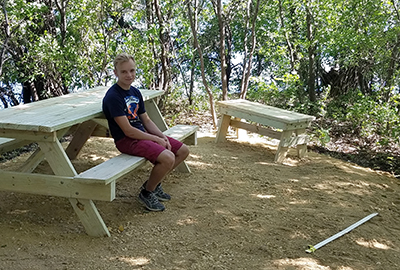
Jake Gombold and members of New Brightons Troop 106 Boy Scouts completed a new sanctuary area at the Waters Edge building. Photo by Brigid Gombold |
In the true spirit of sustainability, Obernolte noted that Jake made a gentle and generous gesture in the landscape.
“Not only is Jake’s path stable, it is also permeable,” said Obernolte. “These young men executed their work so unobtrusively that the egrets weren’t even displaced while the work was going on. Jake’s team was rather light on the land…one step at a time.”
“It is the intention of the Sustainable Garden Team to not only naturalize the landscaping around Waters Edge, but to also offer spaces in which employees can relax and reflect during lunches and breaks and then return to work refreshed,” said Sharon LeMay, Metro District State Aid and Sustainability Team leader. “Sustainability at Metro is about nourishing the land and the mind. This project certainly goes a long ways towards giving Water Edge employees a chance to quickly get out into nature and return to work refreshed.”
Metro Sustainability Team thanks Jake Gombold, New Brighton Troop 106 Boy Scouts, Don Obernolte, Gombold’s family and friends, and the Metro Sustainable Garden Team co-chaired by Joella Givens, MnIT Enterprise Development and Kristina Krepela, RTMC-Freeway Systems, for making this vision reality.
|
|
|
|
|
|
TABLE of CONTENTS
|
Whats new on the web |
Property Management Policy
The new Property Management policy applies to all sensitive items, consumable inventory, supplies, and surplus property under the control or possession of the agency. This policy does not apply to buildings or real property. Policy approved September 2016
Metro District Traffic Engineering Site
We have also made some updates to the Metro District Traffic Engineering site – bringing these pages to the current MnDOT web template and assuring ADA compliance. You will notice some additional navigation items within the top navigation, as well as an addition of helpful sidebars. With these changes, you will also find an updated look to the Metro District Lane Closure Manual site.
Metro District Maintenance Site
Last but certainly not least, we did the same updating to the Metro District Maintenance site. There are new top navigation links and sidebars, as well as a new look and feel.
I-35W/St. Anthony Bridge Site
You will notice updates to the I-35W Bridge pages. There is also a new location for the I-35W Bridge Lighting Schedule page, now located within the I-35W Bridge site. Please make note of this new link (http://www.dot.state.mn.us/i35wbridge/bridgelightingschedule.html) and update your bookmarks accordingly. There is now a redirect from the previous location (under Metro Traffic Engineering Lighting at http://www.dot.state.mn.us/metro/trafficeng/schedule.html) to help our external customers find this new location.
Website updates
If you believe your area’s site is in need of updating to meet ADA compliance and offer a better user-experience, please feel free to contact the web team and we will help arrange a time to meet and discuss. There is also a helpful article in the latest version of the MnDOT Newsline regarding web pages.
New Library Materials
New Library Materials are available at www.mndot.gov/library/newlibmat.html. This issue includes a feature about Microsoft 2013 manuals and video tutorials.
New Library Materials is a compilation of new titles and other resources added to the library collection during the previous month. If you would like to be added to the distribution list, contact Pam Gonzalez at 651-366-3749.
Previous editions of New Library Materials are available at www.mndot.gov/library/recacq-archive.html.
For other information requests, contact the Library at 651-366-3791 or email library.dot@state.mn.us, or send requests via the Ask a Librarian Web page at www.mndot.gov/library/asklibrarian.html.
|
|
|
| |
|