Newsline
Nov. 10, 2020
Newsline Home Newsline Archives Print Newsline Submit News Feedback About Newsline iHub Home mndot.gov Web site

Table of Contents

NEWSLINE HOME

Print Newsline
SELECT ALL or Click checkboxes below to select articles you wish to print.
Use your browser's Reset Button to deselect all.
Headlines TABLE of CONTENTS

Major projects wrap up as 2020 construction season nears an end

Four photos of various road construction projects from around the state

Clockwise from top left: the west bridge pier for the Hwy 12 bridge; crews reconstructing I-35W in the north Twin Cities metro to add MnPASS lanes; crews smoothing out the fresh concrete pavement on Hwy 210 west of Fergus Falls; and a conveyor that is used to move concrete across I-94 between Maple Grove and Rogers. Photos by Paul Rasmussen, Rich Kemp and Emma Olson.

By J.P. Gillach

MnDOT crews worked on or completed more than 200 state road and bridge projects during the 2020 construction season. An additional 51 projects improved railroad crossings or infrastructure at local airports.

“Minnesota’s 2020 construction program represented a broad mix of projects that improved all modes of transportation and provided jobs throughout the state during a challenging year,” said Jay Hietpas, assistant commissioner, Operations. “While COVID-19 created challenges in some areas, the reduced traffic volumes we saw early in the season helped in some cases to minimize disruptions to travelers. We want to thank everyone in both the private and public sectors who helped make this season a success, and worked diligently to keep projects on track.”

Notable projects completed in 2020 include the Hwy 5 “Around the Airport” construction near MSP International Airport; the new Hwy 63 bridge in Red Wing; concrete resurfacing and safety improvements along 18 miles of Hwy 23 between Cottonwood and Granite Falls; and reconstruction of five miles of Hwy 210 west of Fergus Falls. In addition, two important multi-year projects that began in 2020 include the Twin Ports Interchange in Duluth, and improvements to Interstate 94 between Maple Grove and Clearwater.

Construction highlights by region include:

Twin Cities

  • Interstate 94/494/694 in Oakdale, Maplewood, Woodbury – Replaced bridges, repaired pavement and reconstructed lanes for this east metro interchange and bridge safety project.
  • Hwy 169 near Shakopee – Completed the Diverging Diamond Intersection at Hwy 41 and Co. Rd. 78 south of Shakopee.
  • Hwy 21 in Jordan – Completed the United Pacific Railroad bridge, and expected completion of the Sand Creek bridge in November. Both bridges were built in the 1950s.

Northeast Minnesota (District 1)

  • I-35 Lake Avenue Bridge – Resurfaced the Lake Avenue Bridge spanning I-35 in downtown Duluth; improved sidewalks, signals, police and traffic cameras; and added bike lane and left turn lane onto Superior Street.
  • Hwy 53 in International Falls – Completed first year of two-year project that will repair pavement, improve drainage/storm sewer system, improve pedestrian accessibility, build multi-use trail, and add new signal systems and LED lighting.
  • Hwy 1/Hwy 73 – Completed first year of two-year project that will resurface 21 miles of Hwy 1 and five miles of Hwy 73, replace 10 culverts, and realign Hwy 1/Hwy 53 intersection.

Northwest Minnesota (District 2)

  • Hwy 1/Hwy 59 in Thief River Falls – Resurfaced road and constructed two roundabouts. Construction of the Hwy 1/Hwy 59 roundabout will continue in 2021.
  • Hwy 72 International Bridge in Baudette – Completed and opened the new Hwy 72 Baudette/Rainy River International Bridge, in cooperation with the Ontario Ministry of Transportation. Off-roadway work will continue in 2021.
  • Hwy 200 in Laporte – Raised road and installed new culvert to reduce flooding.

Central Minnesota (District 3 and District 4)

  • Hwy 10 in Wadena – Reconstructed road, replaced city water and sewer utilities, improved pedestrian sidewalks and approaches, upgraded signals.
  • Hwy 24 in Annandale – Reconstructed road, replaced city water and sewer utilities, improved pedestrian sidewalks and approaches.
  • Hwy 169 near Milaca – Installed three reduced conflict intersections, improved access.
  • Hwy 210 west of Fergus Falls – Reconstructed from west of I-94 to just east of the Otter Tail/Wilkin county line, resurfaced with concrete, widened shoulders on west end of project, constructed turn/bypass lanes and truck inspection lane, and installed snow fence.
  • Hwy 55 near Barrett – Replaced bridge over the Pomme de Terre River.

Southeast Minnesota (District 6)

  • Hwy 63 in Red Wing – Replaced bridge and constructed new connections to roads on each side of the Mississippi River (Wisconsin and Minnesota). Completion expected in November.
  • Hwy 63/I-90 interchange – Replaced northbound Hwy 63 bridge over I-90, reconstructed I-90 off-ramps to northbound Hwy 63, included acceleration lanes and rerouted Hwy 30 intersection. First year of two-year project.
  • Hwy 60/Hwy 57 roundabout in Wanamingo – Constructed new roundabout.

Southwest Minnesota (District 7 and District 8)

A list of current MnDOT construction projects can be viewed at mndot.gov/roadwork.


Headlines TABLE of CONTENTS

Drive, bicycle with care and walk aware when traveling during dark hours

By Anne Meyer

Photo: a woman walking her dog across the street

Photo by Rich Kemp

Each day from now through late December has less daylight.

That, along with daylight saving time, means more traveling is done in darkness this time of year. Traveling during dark hours contributes to an increase of crashes involving people walking or bicycling.

According to the latest statistics from the National Highway Traffic Safety Association, someone dies while walking or using a wheelchair every 84 minutes in the United States. Crashes with motorists have killed 37 pedestrians in Minnesota so far this year, one more than the same time last year. Ten bicyclists have died in Minnesota, up slightly since 2019.

“It’s more difficult to see people walking or bicycling in the dark, so we see an increased risk for crashes in the fall with less daylight,” said Tori Nill, Office of Transit and Active Transportation director. “We believe implementing proven pedestrian countermeasures, like increasing visibility at crosswalks, can help people travel more safely on our roadways.”

Design changes to vehicles and transportation system have contributed to a decline in motor vehicle fatalities, and MnDOT works every day to see those same results for people who walk and bicycle. Please keep these safety tips in mind:

  • When driving, scan the roadway and sides of a road for people walking or bicycling
  • When walking, check all lanes of traffic for vehicles before crossing the road
  • While bicycling, have a headlight, rear light or reflectors to increase visibility
  • Remember the Minnesota Crosswalk Law, which says people driving must stop for crossing pedestrians at corners and marked crosswalks

Read the full crosswalk law and see additional safety tips on MnDOT’s Safety Education website.


Headlines TABLE of CONTENTS

Geodetic data-sharing garners national recognition

By Joseph Palmersheim

Photo: a surveyor setting up equipment for an observation near a bridge

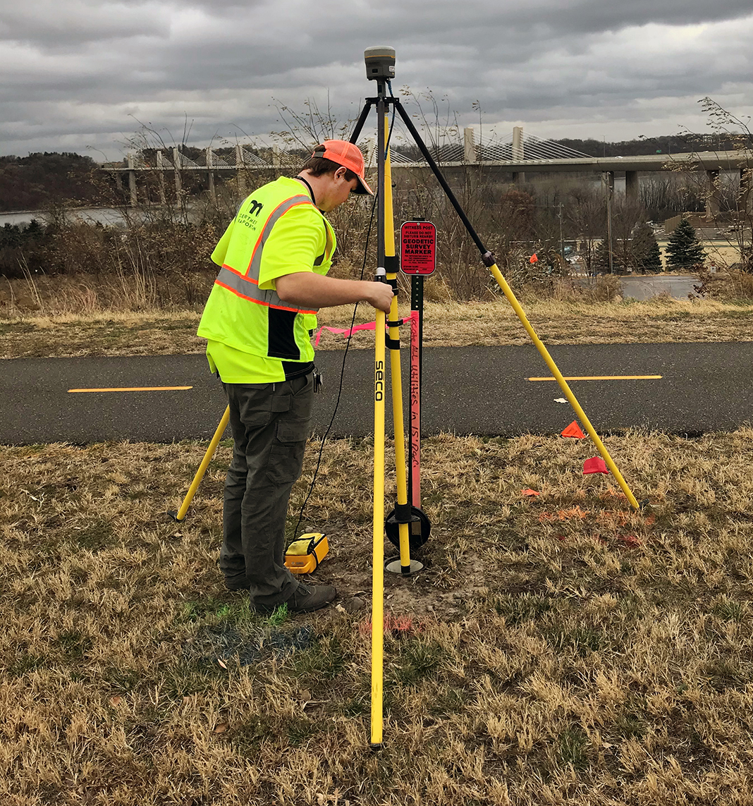
Seth Langer, geodetic field surveyor, sets up his equipment for an observation. Photo by Mike Pemble

Everything MnDOT does to build transportation infrastructure and acquire property starts with geodetic data: a coordinate system and a set of reference points used for locating places.

This data is shared with a variety of partners, including the National Oceanic and Atmospheric Administration.

MnDOT’s geodetic data-sharing partnership with NOAA recently garnered a shout-out on a national level: “Thanks to the herculean efforts at the Minnesota DOT over the past few years, they have accounted for nearly one third of all data submissions to date. Over 2,400 of the completed areas are in Minnesota alone!” according to a write-up in the October edition of NOAA’s Monthly GPSonBM Update.

The Monthly GPSonBM Update documents ongoing improvements made to the local accuracy of NOAA’s National Geodetic Survey’s national scale models. A variety of partners, including state DOTs like MnDOT, provide the data.

“The recognition from NGS validates the time and effort invested,” said Geoff Bitner, Land Management, who is also involved as a liaison with NGS. “This is months and months of work in the field coordinated by Mike Pemble, the geodetic field supervisor, and similar coordinating effort by Dave Streitz, supervisor, Land Management, to manage and prepare the data for submission to NGS. This project is just a cog in the wheel of a much bigger effort currently underway at NGS, so for them to take the time to acknowledge the team effort was really nice.”

The GPS on Bench Marks project aims to update existing benchmarks (points with known height values) and develop a new model without needing additional field work.

MnDOT’s role is to coordinate the field activities, collect the observations and submit the data to NGS. MnDOT also uses this data as the basis for all construction project designs and land acquisitions.

“MnDOT uses this data to connect our property acquisitions and assets to the local and national grids,” Bitner said. “That’s a pretty simple statement, but it’s actually incredible to consider. Imagine every light pole, sign base, bridge pier, catch basin, road edge, highway centerline, etc., is being positioned using various geospatial data collection instruments and can be related through a grid coordinate system that has its roots back to these physical monuments.”

There are a number of other field activities that MnDOT does related to geodetic observations, including:

  • Mark reconnaissance – verifying that the mark (the monument indicating a survey point) still exists, updating the description, updating directions to find it, taking a quick GPS observation for position, and taking updated photos.
  • Monumentation – set new marks that are needed in support of program delivery.
  • Leveling – a traditional method for determining heights using digital leveling equipment.

All of this data is shared through MnDOT’s Geodetic Database, which compiles informational sheets for every station in the state. Both public and private surveyors can access this information.

While there is an electronic component to the work, it starts with someone being in the right place at the right time. Pemble organizes and schedules the GPS field activities. MnDOT has nine full-time employees and up to 11 additional student workers in the summer.

“Since we work all over the state, I need to plan accommodations and make sure all the equipment, from trucks to hammers, is in working order so that everyone can do their jobs,” he said. “Each employee operates up to four GPS receivers per day and is responsible for locating and observing each benchmark. This also includes taking two photos at each benchmark and filling out update-descriptive information and observation log sheets. Each night the crews submit their observation data and photos to me for review and preliminary processing for quality control. Then I post the data for the office to download and process prior to submittal to NGS.”

The monuments need to be durable and stable over time. These can range from a chiseled ‘X’ in a granite ledge, an iron rod driven in the ground, a metal stamped disk, or any number of other permanent objects that can be set in ground in such a way that they’ll remain for years. Some of these monuments are iron rods in the Red River Valley that are more than 100 feet long, driven into the soft soil.

In the end, these monuments, combined with the data, will form the bedrock for a new GPS model that could save the time and expense of having to remeasure in the field.

“The better the model, the less ‘rework’ we’ll need,” Bitner said. “For example, if I have old height values on drainage structures and a good transformational model, I can take those old heights from plans and mathematically transform them using the model and match them into new drainage structures without having to remeasure in the field. This one-time expense will pay dividends over and over in the years to come.  By the developing the best model possible today, it ensures fewer errors in the future.”

NGS will build the 2022 Transformation Tool with data submitted by Dec. 31, 2021.


Headlines TABLE of CONTENTS

Twin Ports Interchange contractor to honor Roberta Dwyer on safety vests

By Margie Nelson, District 1 Public Affairs

Roberta Dwyer, a longtime District 1 engineer who passed away in July 2020, is being honored on safety vests by Ames Kraemer Joint Venture as they work on the Twin Ports Interchange project. Dwyer's initials are above the "AK" on the back of workers' vests. Photo by Ames Kraemer Joint Venture

Roberta Dwyer, a longtime District 1 engineer who passed away in July 2020, will be honored on safety vests by Ames Kraemer Joint Venture, the Twin Ports Interchange project contractor. Dwyer’s initials will be printed on the back of safety vests worn by all contractor staff.

“We were given the opportunity to work with Roberta and got to know her over the last few years as she battled cancer,” said Steve Kaldenbach, project manager with Ames Kraemer Joint Venture. “We admired her dedication to MnDOT and northeastern Minnesota, and it was a way for us to honor her and her legacy. She was very focused, and because of her hard work over her long career, she will be leaving a legacy of many great projects, including TPI.”

Dwyer worked for MnDOT for 39 years in a variety of engineering and managerial positions. This included work as project manager working on development for the Twin Ports Interchange from spring 2016 until her retirement in July. She died away one week after retiring.

“Roberta was such a big part of so many projects, especially this one,” said Pat Huston, assistant district engineer. “Seeing this on the vests is a great daily reminder of all of her impacts.”

The Twin Ports Interchange project - located on Interstate 35 from Garfield Avenue to 27th Avenue West in Duluth – aims to enhance safety by eliminating blind merges and left exits, replace aging infrastructure, and accommodate oversize/overweight loads through the Duluth-Superior Port. Initial construction started in October, with major impacts starting next spring.

The project will be complete in 2023.


Business TABLE of CONTENTS

Pollinator-friendly practices earn North American roadside management award for Environmental Stewardship office

By Mary McFarland Brooks

MnDOT, through the Office of Environmental Stewardship, recently received the 2020 North American Pollinator Protection Campaign award for roadside managers.

The award specified MnDOT’s reduced mowing practices, targeted pesticide uses and the incorporation of 23 native seed mixes into the agency’s roadside vegetation management. The award also cited MnDOT for its participation in the Monarch Butterfly Candidate Conservation Agreement with Assurances, which is the first nationwide voluntary agreement with the U.S. Fish & Wildlife Service to support monarch conservation on energy and transportation lands. In addition, the award recognizes MnDOT’s commitment to long-term management for monarch butterflies on more than 20,000 acres along 11,000 miles of highway, the creation of monarch waystations along I-35 rest areas, and digital educational outreach for National Pollinator Week.

MnDOT currently uses native seed in 57 percent of roadside management plans, with a target of 75 percent by 2025. The agency also includes prescribed fires to enhance native habitat and plant diversity while controlling invasive species.

The NAPPC is a collaboration that includes scientists, researchers, private sector stakeholders, conservationists and government officials working to find common ground on innovative initiatives that benefit pollinators. Its awards are given annually in North America to:

  • Pollinator advocates
  • Farmer-rancher pollinator conservationists
  • Pollinator roadside management programs

“MnDOT is honored to be part of this group of exemplary leaders in pollinator conservation,” said Marni Karnowski, Office of Environmental Stewardship director. “It is so encouraging to see conservationists in farming, advocacy, academia and government working for the same critical cause of pollinator protection and promotion across North America.”

More information about the award


Business TABLE of CONTENTS

Project makes security improvements to Central Office Building

By Joseph Palmersheim                                                                                                           

MnDOT began work in mid-October on a series of security upgrades at Central Office.

The upgrades will be made during the next nine months and include:

  • Installing turnstiles on the Basement, Ground and First floors to limit elevator lobby access to authorized persons
  • Installing a public-access stairway and elevator between Basement, Ground and First floors to allow members of the public to move freely between the public areas of the building on those floors
  • Installing two new banks of gender-neutral, publicly accessible restrooms on Ground and First floors
  • Re-routing the Capitol Complex tunnel in the basement to keep unauthorized persons in public areas only
  • Installing access controls to the Permits and Credentials lobby on First floor
  • Expanding the Ground and First floor Information Desk space to accommodate additional Capitol Security officers during the day

This project has been in the works since late 2016, when MnDOT enlisted a security consulting firm to assist leadership in identifying risks and vulnerabilities in the Central Office building. The first security improvements resulting from the consultant’s risk assessments, including the installation of additional cameras in common and public areas and the securing of the CO motor pool/garage, were made last year.

“The current COVID-19 pandemic provides us with a unique opportunity,” said Stephen Terhaar, facility operations director, Central Office. “With the majority of Central Office likely teleworking through June 2021, we are able to perform this much-needed work while greatly reducing typical issues related to heavy construction, including safety concerns, noise disruptions and a general untidiness. There also are potential cost savings due to the current state of the construction market.”

Work is expected to be finished in June. MnDOT will provide training and best practices for employees who may be returning to the Central Office building around the same time. A project page with more information, including virtual tours and the above training information, is available at ihub.dot.state.mn.us/admin/security/updates.html.


variety TABLE of CONTENTS

On the Job: John Tompkins directs Metro District’s multimodal planning activities

By Rich Kemp

Photo: John Tompkins

John Tompkins. Photo by Rich Kemp

John Tompkins is the multimodal and intermodal planning director for the Metro District. He has worked for MnDOT for 25 years.

What has been your career path at MnDOT?
Before working for MnDOT, I was a freight and household goods supervisor in the U.S. Air Force. While at MnDOT, I have worked in various roles supporting Statewide Planning, Investment Management, Regional Freight Planning, Program Management, and project management in Planning and Project Delivery. I also assisted in structuring and supporting the agency’s Diversity and Inclusion initiatives.

What do you do in your job?
I direct and manage the Metro District’s multimodal planning activities to ensure Trunk Highway plans are integrated in plans for all modes of transportation. This includes regular fixed-route bus service, express bus, light rail transit, commuter rail, bike/pedestrian, aviation, passenger rail, freight trucking, rail, air cargo, ports and waterways.

What is your favorite part about your job?
Bringing awareness and engaging with new stakeholders who have not traditionally been part of the transportation planning and project development process.

What are the biggest challenges?
The biggest challenges would be enhancing and developing performance data to support non-motorized and freight investments. Data can be used to support modal considerations in project planning and development.

What kind of changes have you seen in your job?
A focus to advance efforts that better engage and bring awareness about construction project impacts to non-traditional and traditionally underserved communities.

Has your job changed a lot because of COVID-19?
It has demonstrated the significant advantages of teleworking.

Do you or a co-worker have an interesting job to share with readers? Send us your ideas, and we’ll contact you for more information.

Recent employee profiles:


SELECT ALL or Click checkboxes above to select articles you wish to print.
Use your browser's Reset Button to deselect all.

  TABLE of CONTENTS

NEWSLINE HOME